The South Bohemian Way

Vlašim – Tábor – Český Krumlov – Koranda – 213 km

The South Bohemian route follows the East Bohemian route. It is based on Central Bohemia (or has an alternative beginning from Prague), it always passes through the South Bohemian region in a southwesterly direction with a total length of 213 km. It ends in Šumava on the border with Austria, from where it continues towards Santiago via Passau. On the pilgrimage route you can find 2 churches of St. Jakuba, the world-famous Hluboká chateau, urban conservation areas: Tábor, Bechyně, České Budějovice and Český Krumlov, which is on the UNESCO list.

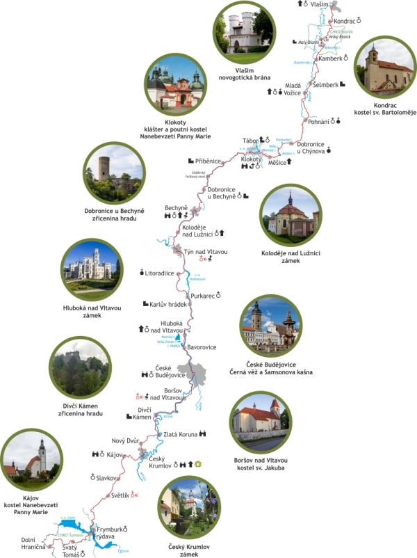
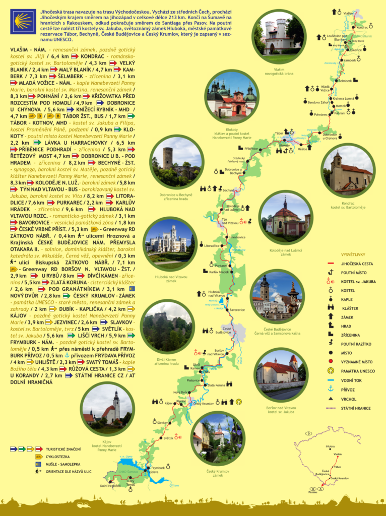
Route map

Route description
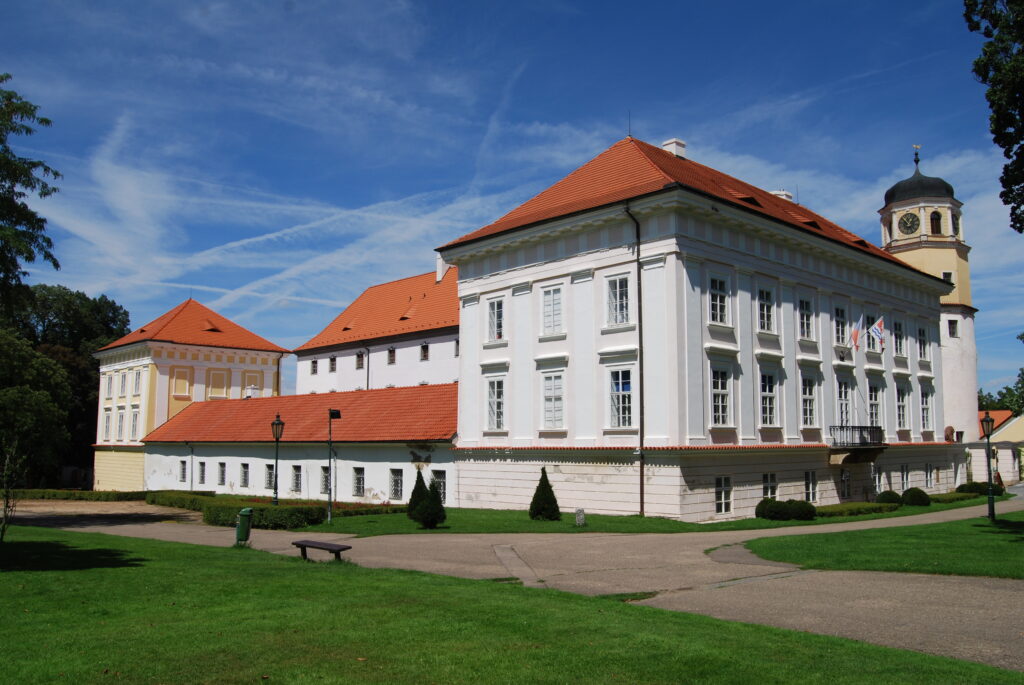
Zámek Vlašim
Autor: Richenza, CC BY-SA 3.0

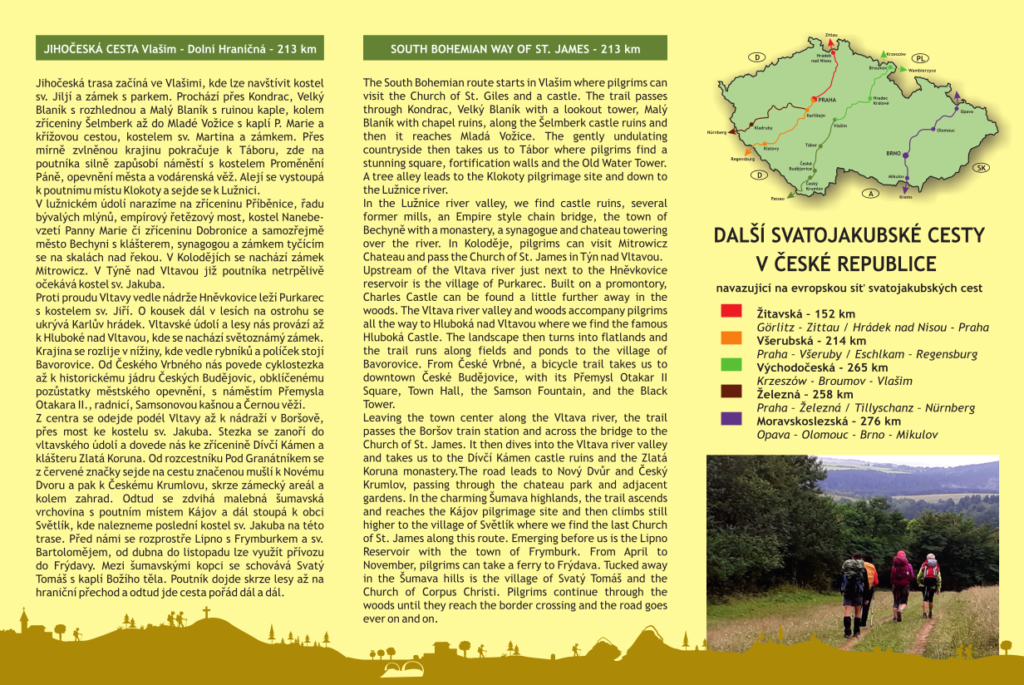
The South Bohemian Way starts in Vlašim. Here, you can visit the Church of St. Giles and a chateau surrounded by park. Passing through Kondrac, Velký Blaník with a lookout tower, Malý Blaník with the ruins of a chapel, and along the remains of Šelmberk, it runs all the way to Mladá Vožice with the St. Mary’s Chapel and the stations of the cross, the Church of St. Martin and a chateau. Through a gently undulating countryside, the way continues to the town of Tábor. Here, the pilgrim is awed by a square with the Church of the Transfiguration, the fortifications and the Renaissance Water Tower. Continue up the tree alley to the Klokoty pilgrimage site and then descend to the Lužnice river.

Hluboká nad Vltavou

Along the Lužnice, we pass the ruins of Příběnice castle, several former mills, an Empire style chain bridge, the Church of the Assumption of Virgin Mary and the remains of Dobronice castle. And naturally, the town of Bechyně with its monastery, synagogue, and a chateau perched high up on the rocks above the river. A Mitrowicz Chateau can be found in Koloděje. And then, the pilgrim is eagerly awaited by the Church of St. James in Týn nad Vltavou.

Upstream of the Vltava river, right next to the Hněvkovice reservoir, lies the village of Purkarec with the Church of St. George. A little further away, the Charles Castle is hiding on a promontory in the woods. The Vltava river valley and the woods are keeping us company all the way to Hluboká nad Vltavou with a world-famous chateau. Then the landscape opens into flatlands, where the village of Bavorovice lies surrounded by ponds and fields. From České Vrbné, follow a cycle route leading to the historical city centre of České Budějovice enclosed by the remains of the fortifications, with its Přemysl Otakar II Square, Town Hall, the Samson Fountain, and the Black Tower.
Český Krumlov

Leave the city centre and follow the Vltava river to the Boršov train station and across the bridge to the Church of St. James. The path then descends into the Vltava river valley and takes us to the ruins of Dívčí Kámen castle and the Zlatá Koruna Monastery. At the Pod Granátníkem signpost, leave the red trail marking and follow the route marked by scallop shells leading to  Nový Dvůr and then to Český Krumlov, through the chateau grounds and past the gardens. From here, the way enters the charming Šumava highlands with the Kájov pilgrimage site and then it rises some more to the village of Světlík. Here we can find the last Church of St. James on this route. The Lipno reservoir, the town of Frymburk and its Church of St. Bartholomew are unfolding before our eyes. From April to November, you can take a ferry to Frýdava. Tucked away in the Šumava hills is the village of Svatý Tomáš with the Chapel of Corpus Christi. Pilgrims continue walking through the woods until they reach the border crossing and from here, the way continues onwards.

Practical information

Itinerary

Kliknutím na turistickou značku se daný segment otevře na mapy.cz

ODKUDKAMKMKM CELKEMZNAČENÍ
Vlašim, náměstí Kondrac 6,46,4
Kondrac Velký Blaník rozhledna4,310,7
Velký Blaník rozhledna Malý Blaník2,413,1
Malý BlaníkKamberk4,717,8
Kamberk Šelmberk 7,325,1
ŠelmberkMladá Vožice, náměstí3,128,2
Mladá Vožice, náměstí Pohnání 8,336,5
PohnáníRozcestí pod Homolí2,639,1
Rozcestí pod HomolíDobronice u Chýnova4,944
Dobronice u ChýnovaKnížecí rybník, MHD5,649,6
Knížecí rybník, MHDTábor, žst. 4,754,3 B/D
Tábor, žst.Tábor Kotnov, MHD1,756
Tábor Kotnov, MHDKlokoty0,9356,9
KlokotyLávka u Harrachovky2,259,1
Lávka u HarrachovkyPříběnice - podhradí6,565,6
Příběnice - podhradíŘetězový most5,370,9
Řetězový most Dobronice u Bechyně - kostel 3,774,6
Dobronice kostelBechyně, žst. 9,283,8
Bechyně, žstKoloděje n. Luž.8,392,1
Koloděje n. Luž.Týn nad Vltavou, bus, kostel sv. Jakuba 5,897,9
Týn nad Vltavou, busLitoradlice8,2106,1
LitoradlicePurkarec7,6113,7
PurkarecKarlův hrádek 2,2115,9
Karlův hrádekHluboká n. Vltavou, rozcestí 9,6125,5
Hluboká n. Vltavou rozc.Bavorovice3,1128,6
BavoroviceČeské Vrbné, přístav1,8130,4
České Vrbné, přístavČeské Budějovice - Sokolský ostrov5,3135,7 RD
České Budějovice - Sokolský ostrovČeské Budějovice - Nám. Přemysla Otakara II. 0,4136,1značeno mušlí
České Budějovice - Nám. Přemysla Otakara II.České Budějovice - Zátkovo nábřeží0,3136,4značeno mušlí
České Budějovice - Zátkovo nábřeží Boršov nad Vltavou, žst., kostel sv. Jakuba 7,1143,5 RD
Boršov nad Vltavou, žstDívčí kámen - zříc. hradu10,9154,4
Dívčí KámenZlatá Koruna5,5159?9
Zlatá KorunaPod Granátníkem2,6162,5
Pod GranátníkemNový Dvůr3,1165,6značeno mušlí
Nový DvůrČeský Krumlov, zámek2,8168,4
Český Krumlov, zámekDubík, kaplička2170,4
Dubík, kapličkaKájov, žel. st.3,5173,9
Kájov, žel. st.Kájov (kostel)1,1175
Kájov (kostel)Jezvinec3,7178,7
JezvinecSlavkov2,6181,3
SlavkovSvětlík, kostel sv. Jakuba 5186,3
Světlík (kostel sv.Jakuba) Liščí vrch5,6191,9
Liščí vrch Frymburk, náměstí5,9197,8
Frymburk, náměstíFrymburk, přívoz0,46198,3neznačeno
Frymburk, přívozFrýdava, přívoz0,62198,9lodí a 135m k rozcestníku
Frýdava, přívozUhliště3,9202,8
UhlištěSvatý Tomáš 2,3205,1
Svatý Tomáš Růžová cesta4,3209,4
Růžová cesta U Korandy1,3210,7
U KorandyHraniční přechod Dolní Hraničná CZ/A2,7213,4
Celkem213,4 km

červená modrá zelená žlutá turistické značky KČT / touristic trails

cyklo silnice cyklotrasa po silnici / cycling route on paved road

Cyklo po cestě cyklotrasa po nezpevněné cestě / cycling route on unpaved road

razitko razítko / stamp

Alternativní trasa

Na Jihočeskou trasu můžete zvolit také alternativní příchod z Prahy.

Accommodation

Níže uvádíme přehled cenově nejdostupnějších ubytování na trase. Obzvlášť ve větších městech najdete i další možnosti. Ubytování je vždy nutné rezervovat alespoň dva dny předem. Všechny uvedené informace mají informativní charakter a neneseme odpovědnost za jejich neaktuálnost. Pokud narazíte na nějakou nesrovnalost, využijte kontaktní formulář níže na stránce. Děkujeme. Poslední aktualizace: Česko v dubnu 2024, Rakousko v květnu 2023.

MěstoKontakt
VlašimSpolkový dům, tel.: 733 603 726, 470 Kč / osoba, 840 Kč / 2L pokoj
KondracU blanických rytířů, tel.: 602 388 381, 400 Kč / osoba
Ubytovna Kondrac, tel.: 721 935 769, 300 Kč / osoba
Penzionu Scarlet, tel.: 720 560 255, 1 200 Kč / 2L pokoj (pouze sezónní provoz)  
Dolejší MlýnBioFarma Dolejší Mlýn, tel: 777 938 568, 500 Kč / noc v maringotce nebo 1.000 Kč / noc v apartmánu
Mladá VožiceHotel Záložna, tel.: 602 135 606, 600 Kč / osoba - do 6/24 v rekonstrukci, ubytování min. na 2 noci
Knížecí rybníkkemp Knížecí rybník, tel.: 606 823 746, chatky a hospoda v kempu, otevřeno duben až říjen, 3-lůžková chatka od 650 Kč / noc, 4-lůžková chatka od 800 Kč / noc
Sezimovo ÚstíPenzion U růže, 690 Kč / osoba / 1L pokoj, tel.: 727 894 435, v obci i další možnosti, přehled zde
TáborFarní úřad CČSH, tel.: 602 117 174,
Poutní dům Emauzy, tel.: 731 139 306 
Hostel při ZŠ Bernarda Bolzana, 420 Kč / osoba 
Tábořiště Harrachovka, tel.: 776 355 229, 500 Kč / osoba
PříběnicePenzion Příběnice, tel.: 603 570 024, 810 Kč se snídaní / osoba
BečiceRekreační středisko Stavorek, tel.: 602 379 404, chatka 300 Kč / osoba (bez záruky, nepodařilo se kontaktovat)
Kemp country Bečice, tel.: 777 000 400, e-mail: jindrich.smazik@seznam.cz, 80 Kč / osoba + 80 Kč / stan
Saloon Lužnice, tel.: 607 119 380 (pouze sezónní provoz) (bez záruky, nepodařilo se kontaktovat)
Dobronice
u Bechyně
Kemp Dobronice u Bechyně, tel.: 737 450 825, 280 Kč / stan, 1 350 Kč / chatka (bez záruky, nepodařilo se kontaktovat)
BechyněFara, po předložení credenciálu, karimatka a spacák, tel.: 731 402 939 (není na trase cca 6 km od Bechyně)
Další možnosti uvedeny zde.
HvožďanyKemp Orion, tel.: 721 771 354, chatka, stan
Kemp Cihelna, tel.: 603 339 633, 777 253 265 (není na trase, cca 2 km od Bechyně mimo trasu) , 400 Kč / noc
Koloděje nad LužnicíCamping Prima, pouze celý bungalov, tel.: 725 025 075
Týn nad VltavouPenzion u sv. Kateřiny, tel.: 723 982 450, 450 Kč / osoba  
Další možnosti ubytování zde.
HněvkoviceKemp Rusalka, tel.: 605 898 752, srub 700 Kč / osoba, chata 500 Kč / osoba
PurkarecPenzion Vltavan, tel.: 723 937 009 , 550-800 Kč / osoba, sleva s vlastním spacákem
Hluboká nad VltavouPrivát Jan Frdlík, tel.: 606 661 362, od 400 Kč / osoba
Kemp Křivonoska, tel.: 725 959 497, 240 Kč / osoba ve stanu včetně stanu, 360 Kč / osoba v chatě
Kemp a hotel Barborka, tel.: 607 117 026 
České VrbnéKemp a hostel České Vrbné, 360 Kč / noc v hostelu (objednávky pouze na e-mailu info@raftingcb.cz)
České BudějoviceUbytovna U nádraží, tel.: 734 200 826, od 620 Kč / osoba
Boršov nad VltavouVodácký kemp a ubytovna Poslední štace, tel.: 602 272 659 (sezónní provoz)
Dívčí kámenTábořiště Dívčí kámen, tel.: 775 213 959, 773 047 377 (sezónní provoz)
Penzion Hamr, tel.: 778 098 898, od 1 125 Kč / osoba
Zlatá KorunaKemp u Kučerů, tel.: 777 140 146, 180 Kč / stan a 180 Kč / osoba, 1 300 Kč / 4L chatka,
Hospoda na Kovárně, , Rájov, cca 1,5 km od kláštera mimo trasu, (aktuálně změna majitele, ubytování bez záruky)
Rekreační chata Rájov, tel.: 777 749 327 (bez záruky, nepodařilo se kontaktovat)
Kemp Koruna, tel.: 777 729 444, hostel o 10 lůžkách (min. obsazenost 8) 250 Kč / osoba
Hostinec na Letné, tel.: 730 190 254 (cca 1,6 km od kláštera směr Kleť), 1 290 Kč / 2 osoby (dočasně uzavřeno)
Český KrumlovKemp Krumlov, tel.: 720 514 943, 160 - 190 Kč / osoba a 160 - 190 Kč / stan
Kemp Nové Spolí, tel.: 777 640 946, 380 728 305, od 120 Kč / stan + 180 Kč / osoba, 1 400 Kč / 4L - 8L chatka
KájovKlášter Milosrdných sester sv. Kříže, tel.: 605 135 579, dobrovolný příspěvek, nutný kontakt předem!
Kájovská hospoda, tel.: 606 421 395, 530 Kč / noc, 960 Kč / 2 osoby  
Petráškův Dvůr, Křenov, tel.: 725 474 711, 602 130 418, 150 Kč / stan a 130 Kč / osoba, (cca 2 km mimo trasu)  
Frymburk Kemp Vřesná, tel.: 602 255 733, 550 Kč / 4L chata, možnost přespání na terase
Přední VýtoňPension Vyhlídka, tel.: 606 393 659, 650 Kč / osoba (dvoulůžkový pokoj)
Rakousko 
Aigen-SchläglStift Schlägl, Pilgerherberge, tel.: +43(0) 7281 8801 221, 41 EUR (po předložení credencialu)
Rohrbach BergLandgasthof Dorfner, Pilgerhreberge, tel.: +43(0) 7289 4332, 40 EUR
Informace pro poutníky: Tourismusverband Böhmerwald, Stadtplatz 1, tel.: +43(0) 5789 0310)

Pfarrkirchen in MühlkreisPrivatzimmer, tel.: +43(0) 6648 7066 24, Rosa Scherrer, 22 EUR
Leaflet to download

Daily Stages

Stage 1. Vlašim - Mladá Vožice

Stage 1. Vlašim - Mladá Vožice

From: Vlašim - Main Square
To: Mladá Vožice - Main Square

Length: 28,8 km
Height profile: 824 m 739 m

Interactive route map

Route description

The route is quite long and contains challenging ascending. You can divide this stage into two. However, there is no accommodation between Vlašim and Mladá Vožice apart from Kondrac, which is quite close to the starting point. However, you can leave the path to Louňovice pod Blaníkem, which is approximately in the middle of this route.

The South Bohemian Way starts at the very point where the Eastern Bohemian way finishes, i.e. at Hus square in Vlašim. You can visit the chateau here as well as the adjacent park, alternatively you can divert form the path to Domašín to the church of St. James and come to the path marked by red. You will stay on the red path for some time and it will take you out of the town centre of Vlašim through the town buildings heading towards South. Cross the railway tracks, pass the villa quarter and leave the town. Enjoy walk through apple tree alley surrounded by fields. Follow the Orlina River from a distance, pass two ponds and before reaching the third one turn on the dam in south-west direction. Reach Kondrac where there is a medieval church of St. Bartholomew and then carry on passing Brodec Creek to Velký Blaník where there is a watchtower. Then continue to Malý Blaník where you will find ruins of St. Margaret´s Chapel. Following those two challenging climbs you will benefit from mild descend through Býkovice to Kamberk where there is a church of St. Martin. You will continue through the forest and get to the ruins of Šlemberk castle. You can find pilgrim´s stamp in a pilgrim´s box on the signpost at the parking lot. Then continue to Mladá Vožice.

Points of Interest

Vlašim - Castle and adjacent park
Vlašim - St. Giles´ church
Vlašim - St. James´s church
Kondrac - Medieval church of St. Bartholomew
Šelmberk – Castle ruins
Mladá Vožice - Points of Cross
Kamberk - Baroque church of St. Martin
Mladá Vožice - Rennaissance castle


Stage 2. Mladá Vožice - Klokoty

Stage 2. Mladá Vožice - Tábor Klokoty

From: Mladá Vožice - Main Square
To: Tábor - Klokoty

Total Length: 28,6 km
Hight Profile: 442 m 445 m

Interactive route map

Route Description:

It is a kind of a longer stage containing mainly moderate superelevations. It leads through open landscape and in its second half is cutting through the highlands forests westway from Tábor.

Starting from St. Martin´s Church, take Táborská Street and follow the red sign. Just before the end of Mladá Vožice turn into southwest direction taking you to Obránců míru Street and then carry on into the fields towards South. Join the road for a short period and then turn into farm road towards Klapův mill. Cross the Blanice River there and carry on into the fields to Krchova Lomná and Bendovo Záhoří. After passing Mostek village get back down to Blanice River valley. Be very careful here as the red path is not marked very well in this part of the route. You need to cross the river at the influx and the route is running about 100 m on a path, which is following this influx running towards southeast. Then turn west and climb up the hill until you reach village Pohnání and its church of St. Procopius. There you can find the pilgrim stamp in the pilgrim´s box on the inner cemetery wall.

From Pohnání walk on the road, pass Pohnánec village, Polánka fortress until you reach Ratibořské Hory–statek Polánka bus stop where you leave the road and follow the blue sign southway into an alley cutting through the fields. Going through the fields and forests of Dubské Vrchy (Oaktree Highlands) you will reach Dobronice u Chýnova. Follow the signs through the fields and Chotovinský Creek until you enter Velký Hutecký forest and reach Knížecí (Prince´s) Pond. The marked route ends here and St. James´s Way follows the cycleway D through Měšice untill two railway bridges. Passing them you will turn towards southwest and follow the cycleway B to Tábor railway station. From there follow the green sign towards its historic centre which you will bypass on formal fortification passing St. James and Phillip´s Church and Kotnov castle. Then turn back towards the town centre through Kotnovská gate and descend to Tismenické valley where you will reach a stunning linden alley leading towards Klokoty pilgrimage site. There is Our Lady of Assumption Church as well as the pilgrims Guest House Emauzy where you can spend a night. 

Points of Interest:

Pohnání - St. Procopius Church with romanesque features
Měšice - chateau
Tábor- town fortification
Tábor - Renaissance Watertower
Tábor - Transfiguration of Our Lord Church
Tábor - Underground system
Tábor - Hospice and Chapel of St. Ann
Tábor - Old Town Hall
Tábor - St. James and Phillip´s Church
Kotnov - Castle
Klokoty – Pilgrim Site

Stage 3. Klokoty - Bechyně

Stage 3. Tábor Klokoty - Bechyně

From: Tábor - Klokoty
To: Bechyně náměstí

Total Length: 27,9 km
Hight Profile: 394 m 442 m

Interactive route map

Route Description:

This stage follows Lužnice River and its profile is plain apart from couple of climbs to the views over the river.

Starting from pilgrim site Klokoty, pass the forest at the beginning of Lužnické valley and follow the green marking until you reach the rocky pinacle above Harrachovka. Descend to the valley and take the little concrete bridge to cross the river. At the crossroads, take the path following the river, which is marked in red. The terrain is not challenging, however the path may be muddy in winter or after intensive rains. Also, some parts closer to Bechyně may be unkempt. You may be taken by surprise by a tunnel in the rock, which was dug by the Club of Czech Tourists in 1939, and by the bridge over the river alongside the rocks. There are ruins of Příběnice castle hidden behind the rocks as well as a pension where you can take some refreshment. Then follow the path into the woods, pass Bejšovcův mill, several camping sites and chalets, Suchomelův mill and at last the Stádlecký Empire Bridge. Leave the river behind and climb up to the medieval Chapel of Our Lady Assumption where you can find another pilgrims box with a pilgrim stamp. From there it is very close to Dobronice village and ruins of its castle. Descend to the valley and then ascend towards Bechyně cemetery. You can either take a shortcut directly to the town on the road or follow the red marking down to Lužnice River and Bechyně waterfall and then climb up to Bechyně and its Rosenberg Renaissance chateau. 

Points of Interest:

Příběnice - Ruins of the Castle
Stádlec - Empire Bridge
Dobronice - Kostel Nanebevzetí Panny Marie
Dobronice - Ruins of the Castle
Bechyně - Synagogue
Bechyně - Jewish Cemetery
Bechyně - St. Michael Church
Bechyně - St. Matthias Church
Bechyně - Fraciscan Monastery
Bechyně - Chateau
Bechyně - Town Fortification

Stage 4. Bechyně - Purkarec

Stage 4. Bechyně - Purkarec

From: Bechyně - náměstí
To: Purkarec

Total Length: 29,8 km
Hight Profile: 384 m 420 m

Interactive route map

Route Description:

This stage is not challenging. The only uncomfortable part may be the walk alongside the Vltava River in the summer months as there is no shade there.

By descending from Bechyně you will again enter the Lužnice valley and will walk in the woods almost till you reach Koloděje. Then the path will lead you up the hill where you can observe from apart influx of Lužnice and Vltava Rivers. Descend from there to Týn nad Vlavou. You will find St. James´s church there and you can enter its tower from the main square side and find inside a pilgrims stamp. From there follow the westway side of Vltava River towards South, towards Hněvkovice and a reservoir of the same name, then climb up to Litoradlice. This part of the route does not provide for any shade during the summer months so it is advisable to avoid it during hot periods. Then get through the woods around Hřeben hill and you will get back to the reservoir, which buried into its waters the majority of the Purkarec village. There you can visit Museum of Floating Wooden Rafts.

Points of Interest:

Koloděje nad Lužnicí - Jewish Cemetery
Koloděje nad Lužnicí - Baroque Chateau
Týn nad Vltavou - St. Vitus Church
Týn nad Vltavou - St. James´s Church
Purkarec -  St. George´s Church

Stage 5. Purkarec - České Budějovice

Stage 5. Purkarec - České Budějovice

From: Purkarec
To: České Budějovice - Náměstí Přemysla Otakara II.

Total Length:  22,5 km
Hight Profile:  272 m 265 m

Interactive route map

Route Description:

This stage is medium length flat route containing two hills, i.e. next to Karlův Hrádek and by Hluboká. 

Leaving Purkarec join the woods of Vltava River and follow the red marking. Get to Karlův Hrádek (Charles Little Castle) founded by Charles IV. You can find another pilgrims box with a stamp in there. From there take the tar cycleway alongside the Vltava valley all the way up to Hluboká where here is a moderate ascending. The pilgrim route leads through the chateau park and you can enjoy a chateau visit as they offer a number of tours. Alternatively, you can refresh in local brewery. From there take the amazing oak tree alley, then pass the ponds and fields until you reach Bavorovice. There you can admire beautiful gables of the local houses. Still carry on alongside the river all the way up to České Vrbné where the red marking ends and you need to start following the cycleway Greenway RD on which there is an additional marking with St. James´s Shell. Those markings will take you to Sokolský Island and Malše tributary. From there take Hroznová street which leads to the city centre of České Budějovice and then through Krajinská Street to Přemysl Otakar II. Square. 

Points of Interest:

Karlův hrádek – Ruins of a Castle
Hluboká - Gothic Castle
Hluboká -  St. John of Nepomuk Church
Bavorovice
České Budějovice - Salt Cellar – Arsenal
České Budějovice - Dominican Monastery
České Budějovice - Town Hall
České Budějovice - Přemysl Otakara II Square with Samson Fountain
České Budějovice - Černá (Black) Tower
České Budějovice - St. Nicolas Church
České Budějovice - Chapel of the Mortal Anxiety or Our Lord
České Budějovice - Salt Cellar
České Budějovice - City fortification

Stage 6. České Budějovice - Zlatá Koruna

Stage 6. České Budějovice - Zlatá Koruna

From:  České Budějovice
To:  Zlatá Koruna

Total Length:  23,8 km
Hight Profile:  427 m 331 m

Interactive route map

Route Description:

This stage can be divided into two parts in case you will find it difficult. The first part is flat up to Dívčí kámen and only contains one moderate climbing up to the hill. On the other hand, the second takes you to the hills where you will be constantly going up- and downhill.

The South Bohemian path leaves from the Přemysl Otakar II Square in České Budějovice around the Town Hall and takes Biskupská Street, passes Malše River and a little park with the observatory and then joins Vltava River. Take again the cycleway Greenway RD, which is also marked with the shell and follow it to Boršov nad Vltavou to the medieval church of St. James. There is the pilgrim stamp in the church. The way takes the shape of meandering river with seldom climbing, most of the time through the greenery until it reaches ruins of the stunning castle Dívčí kámen (Maiden Rock) on a rocky pinnacle. Climb up towards Třísov and Plešovice where you will descend back to the river all the way to Zlatá Koruna (Golden Crown) and its amazing monastery.

Points of Interest:

Boršov nad Vltavou - St. James´s Church
Ruins of the Castle - zřícenina hradu
Zlatá koruna - Cistercian Monastery

Stage 7. Zlatá Koruna - Kájov

Stage 7. Zlatá Koruna - Kájov

From:  Zlatá Koruna
To:  Kájov

Total Length:  14,6 km
Hight Profile:  440 m 375 m

Interactive route map

Rout Description:

A short stage in an ups and downs terrain in which there is a remarkable town Český Krumlov, UNESCO listed. It is worthwhile to spend some time wondering through the town.

Take the red marking from Zlatá Koruna monastery to the railway track and all the way to crossroads Pod Granátníkem. Leave the red marking at this point and follow the shell marking to Nový Dvůr and from there on green mark to Český Krumlov. Enter the town through Budějovická gate, pass the Trojklášteří (Three Monasteries) building complex and reach the renaissance castle/chateau Český Krumlov. Follow the yellow mark throughout the chateau building complex, pass the chateau gardens until you reach the picturesque highlands where there is pilgrim site Kájov.

Points of Interest:

Český Krumlov - Budějovická gate
Český Krumlov - Trojklášteří (Three Monasteries)
Český Krumlov - Marian Column
Český Krumlov - Town House
Český Krumlov - Synagogue
Český Krumlov - St. Vitus church
Český Krumlov - Chateau
Český Krumlov - Original Baroque Theatre
Kájov - Church of Our Lady Assumption

Stage 8. Kájov - Frymburk

Stage 8. Kájov - Frymburk

From:  Kájov
To:  Frymburk - náměstí

Total Length:  22,8 km
Hight Profile:  446 m 266 m

Interactive route map

Route Description:

A very difficult stage due to a number of ascending meters in its first half. It gets easier at Světlík as the path descends in a moderate way and leads mainly through the woods. 

The path follows the yellow mark from Kájov, which changes at Jezvinec crossroad for blue. It goes uphill all the way to Slavkov. You can take a rest at Slavkov in the shades of St. Bartholomew´s church and the local fortress. Further up on blue marking reach the village of Světlík where there is the last St. James´s church on the Czech territory. On the outside wall of the cemetery you can find a pilgrim stamp in a pilgrim box . Then walk down from this village on the top of the hill (800 m high) all the way down through the fields and then woods until you reach Lipno reservoir and Frymburk with a church of St. Bartholomew with an amazing tall bell tower. 

Points of Interest:

Slavkov - Vicarage and Fortress
Slavkov - St. Bartholomew´s Church
Pasovary - Ruins of a Fortress
Světlík - St. James´s Church
Světlík - Cross Stops
Frymburk -  St. Bartholomew´s Church
Frymburk - Marian Column

Stage 9. Frymburk - Dolní Hraničná

Stage 9. Frymburk - Dolní Hraničná

From:  Frymburk - náměstí
To:  Hraniční přechod Dolní Hraničná CZ / AT

Total Length:  15,6 km
Hight Profile: 310 m 307 m

Interaktivní mapa trasy

Route Description:

A hilly stage containing the highest point of all St. James´s routes in the Czech Republic, which is in village Svatý Tomáš (Saint Thomas). This stage is surprisingly not very demanding because the starting point in Frymburk is already in 700 m high. Also, the part between Svatý Tomáš and the country border leads through the moderate terrain in the woods.

This stage contains two perils, which are:

Firstly, the ferry from Frýdava operates only from April to November. Apart from those months, it is necessary to walk alongside Lipno Reservoir, it means that the 16km stage turns into the 31km one. You will have to follow the green marking to Lipno nad Vltavou village and then on blue to crossroads U Překopané and from there to take red to Uhliště where you join the original track.

Secondly, it is not very easy to come back to civilisation from Dolní Hraničná in case you decided to travel within the Czech boarder only. In a nutshell, it is necessary to go back to Frymburk, i.e. 34km, or to travel to Horní Planá, i.e. 40 km.
However, if you successfully sail over to Frýdava there is a yellow marking ready for you to take you all the way to crossroad Uhliště and from there you will follow the red one. The village Svatý Tomáš (Saint Thomas) is hidden in the Šumava mountain hills. There you will find Corpus Christi Chapel and pilgrim box attached to the info sign. The castle ruins of Vítkův kámen (Vitus Rock) are not far away from there. Climb down through the woods following the red and then the yellow marks, pass the crossroad Růžová cesta, Schwarzenber water canal until you reach crossroad U Korandy. The rest of the Southbohemian Way runs on blue marking through the back country woods and meadows all the way to Dolní Hraničná and then to Passau (Pasov) and Santiago.

Points of Interest:

Svatý Tomáš - Corpus Christ Chapel
 Vítkův Kámen - Ruins of a Castle

Zápisky poutníků

Přečtěte si reportáž o pouti Tomáše J. Kouby v létě 2011